Queenstown to Christchurch: the three route options
What's the best route from Queenstown to Christchurch?
The inland route via Lake Tekapo and Aoraki/Mount Cook is shortest at around 480 to 500 kilometres, but still needs six to eight hours behind the wheel once you add stops. The coastal route via Dunedin and Oamaru, and the west route via Franz Josef and Arthur's Pass, are both longer and are better treated as two-day drives rather than one long day.
Three routes, one blunt truth: budget a full day
There is no quick way from Queenstown to Christchurch. The straight-line distance across the South Island is deceptive on a map, because there is no straight road: every option threads through mountains, and the shortest of the three still runs to 480 to 500 kilometres. Treat six to eight hours as the minimum driving time on the fastest route, not the average, and treat the other two routes as two-day trips unless you are starting before sunrise and stopping for nothing.
The three options are an inland route via Lake Tekapo and Aoraki/Mount Cook, a coastal route via Dunedin and Oamaru, and a western route via Franz Josef and Arthur’s Pass. They go to the same place but see almost nothing in common along the way, so the right choice depends on what you have already done and how much time you actually have, not which one looks shortest on a map app.
One thing all three share: satnav and map apps routinely underestimate driving time on these roads. Treat their estimate as a floor, not a plan, and add 20 to 30 percent for a realistic figure once you include fuel stops, photo stops and the odd stretch of roadworks. For general driving conventions on South Island roads, see driving in New Zealand: South Island.
Route 1: inland via Lake Tekapo and Aoraki/Mount Cook
This is the shortest route by distance and usually the fastest, and it is the one most people mean when they ask for directions to Christchurch. From Queenstown it runs through Cromwell, over the Lindis Pass, through Omarama and Twizel, past Lake Pukaki and Lake Tekapo, then on through Fairlie and Geraldine to Christchurch.
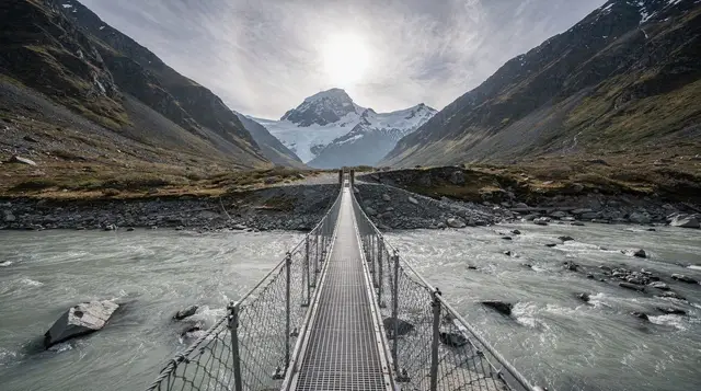
Aoraki/Mount Cook sits just off this route: Queenstown to the village at the base of the mountain is around 265 kilometres, about three and a half hours, via Cromwell, the Lindis Pass, Omarama and Twizel. It is a genuine detour rather than a drive-by, adding roughly an hour each way if you turn in, but it is the only one of the three routes that gets you anywhere near New Zealand’s highest peak. If you have the time, the short, flat Hooker Valley Track is the reason to make the detour rather than just photographing the mountain from the highway.
Lake Tekapo itself is about the same distance from Queenstown, roughly 265 kilometres and three hours, on a slightly more direct line than the Mount Cook detour. Its turquoise water comes from glacial flour suspended in the lake, and it sits inside the Aoraki Mackenzie dark sky reserve, so it is worth a stop even if you are not staying the night; see stargazing at Tekapo if you want to time your drive around it.
From Tekapo, the remaining stretch to Christchurch through Fairlie and Geraldine runs to roughly 230 kilometres, around two and three-quarter hours on a good run. Add it up and the inland route comes to somewhere around 480 to 500 kilometres door to door, with a non-stop drive time in the order of six to six and a half hours. Realistically, once you stop for fuel, food, and even a short look at Tekapo or Pukaki, budget seven to eight hours minimum, and closer to nine or ten if you detour into Aoraki/Mount Cook village.
For those doing this drive as a dedicated trip rather than a pass-through, see Queenstown to Mount Cook and the four-day Queenstown to Christchurch itinerary, which spreads the same route over two nights with proper time at Mount Cook and Tekapo instead of a single long push.
Route 2: coastal via Dunedin and Oamaru
This route heads south first, not north-east, which surprises people who assume Christchurch is a straight shot. From Queenstown it runs to Dunedin, around 280 kilometres and three and a half hours, then follows the coast north through Oamaru before turning inland to Christchurch.
It is the route to choose if you want to see the Otago Peninsula, home to the world’s only mainland colony of royal albatross alongside yellow-eyed penguins and fur seals, or Dunedin’s Edwardian architecture and its 1906 railway station. Continuing north from Dunedin, Oamaru’s whitestone Victorian precinct and its steampunk scene are around an hour and a half further, and the Moeraki Boulders — spherical rock formations up to nearly two metres across, best seen at low tide — sit just south of Oamaru and are worth timing your drive around rather than arriving to find them underwater.
From Oamaru, the final leg north to Christchurch runs to roughly 245 kilometres, about two and three-quarter hours. All up, the coastal route comes to somewhere around 630 to 650 kilometres, noticeably longer than the inland route despite feeling like the more direct option on a map, because you are tracing the coastline rather than cutting through the middle of the island. Non-stop driving time sits at eight hours or more, and that is before any of the stops that make this route worth choosing in the first place.
Given the distance, this is the route where splitting the drive genuinely helps rather than just being a nice idea: an overnight in Dunedin or Oamaru turns a gruelling single day into two comfortable ones, with room for the Otago Peninsula’s wildlife or an evening in Oamaru’s old town. See Queenstown to Dunedin for the southern leg on its own.
Route 3: west via Franz Josef and Arthur’s Pass
The third option goes the opposite direction again, this time north-west along the West Coast before cutting back east through the Southern Alps. From Queenstown it runs via Wanaka and Haast Pass to Franz Josef, around 350 kilometres and five and a half hours on its own, before the route turns inland on State Highway 73 through Arthur’s Pass to Christchurch, another roughly 300 to 330 kilometres and four to four and a half hours.
Put together, that is somewhere in the order of 650 to 680 kilometres and nine and a half to ten hours of driving before you factor in a single stop, which makes this comfortably the longest of the three routes in time, even though its distance is similar to the coastal option. This is not a route to attempt in one day. Treat it as a minimum two-day trip, with Franz Josef or nearby Fox Glacier as the natural overnight stop, and see Queenstown to Franz Josef and the four-day west coast glaciers itinerary for how to structure it properly rather than rushing.
The reward for the extra time is genuine: Haast Pass, temperate rainforest running almost to the glacier terminals, and Lake Matheson’s reflection of Aoraki on a calm morning. If glacier country and the West Coast are on your list regardless, this route lets you tick them off en route to Christchurch instead of as a separate side trip from Queenstown. If you are choosing between Franz Josef and Fox Glacier as your stop, see Franz Josef vs Fox Glacier first.
Arthur’s Pass itself is a genuine alpine crossing, not a formality: it can close for snow, slips or flooding, particularly outside the summer months, so check current conditions before you commit to this route rather than after you have already driven five and a half hours to get to Franz Josef.
Comparing the three routes
| Route | Approx. distance | Non-stop drive time | Realistic time with stops | Best for |
|---|---|---|---|---|
| Inland via Tekapo & Aoraki/Mount Cook | 480–500 km | ~6–6.5 hrs | 7–8+ hrs (one day, if pushed) | Shortest option; Mount Cook and Tekapo |
| Coastal via Dunedin & Oamaru | 630–650 km | ~8 hrs | 9+ hrs, better as 2 days | Otago Peninsula wildlife, Moeraki Boulders |
| West via Franz Josef & Arthur’s Pass | 650–680 km | ~9.5–10 hrs | 2 days minimum | Glacier country, Haast Pass, West Coast |
None of these figures assume traffic, roadworks, or the kind of weather that closes Arthur’s Pass or the Lindis Pass for a few hours. Build in slack, especially outside the December to February window when daylight is shortest and mountain weather is least predictable.
Doing it as a one-way tour instead of self-driving
If ten hours behind the wheel is not how you want to spend your last days in New Zealand, several operators run one-way tours from Queenstown to Christchurch that cover the driving for you and build in stops a self-drive itinerary would otherwise force you to skip.
On the inland route, a guided day tour that takes in Aoraki/Mount Cook on the way through to Christchurch covers the ground in a single day with the Mount Cook detour already built in, which is hard to manage solo without an early start. There is also a one-way transfer via Wanaka, Mount Cook and Lake Tekapo for those who want the same inland route with a Wanaka stop added at the start.
For the west route, a two-day one-way tour via Franz Josef splits the drive across two days with an overnight in glacier country, which matches how this route should be done rather than compressing it into one long push. There is no packaged one-way tour covering the coastal route via Dunedin and Oamaru in the current lineup, so if that is the route you want, self-driving with an overnight stop remains the practical option.
Booking a one-way tour also sidesteps the rental car relocation fee that comes with a one-way self-drive; see car rental in Queenstown for how that fee typically works and what it costs.
Flying instead of driving
Queenstown Airport runs direct flights to Christchurch, and the flight itself takes around an hour, against a minimum of six hours by road on the fastest route. If you have already covered the ground you want to see — Tekapo on the way south, say, or the West Coast on an earlier trip — flying is the sensible choice rather than repeating scenery you have already driven past. It also removes the rental car relocation fee entirely if you are not planning to drive further in the South Island. The trade-off is obvious: you see nothing between the two cities, and on a clear day that is a genuine loss, since all three routes pass through some of the more striking landscape in the country.
One route not on the way: Milford Sound
It is worth saying plainly: Milford Sound is not on any of these three routes, and Skippers Canyon is not either. Milford sits south-west of Queenstown down a dead-end road, so a trip there and back adds a full day in the opposite direction from Christchurch, not a detour on the way. If Milford is still on your list, do it from Queenstown before you leave rather than trying to work it into a departure day; see the Milford Sound day trip from Queenstown for how to plan it, and treat it as a separate outing entirely from whichever Christchurch route you choose.
Which route should you actually choose
If time is short and you simply need to get to Christchurch, take the inland route via Tekapo. It is the shortest by distance and time, it can genuinely be done in one long day if you start early, and Aoraki/Mount Cook is worth the detour if you have not seen it from Queenstown already. This is also the route best supported by one-way tours if you would rather not drive it yourself.
If wildlife and heritage architecture matter more than saving hours, take the coastal route via Dunedin and Oamaru, but plan on two days rather than one — the distance alone makes a single-day push a bad idea, and rushing past the Otago Peninsula or the Moeraki Boulders to make Christchurch by evening defeats the point of choosing this route in the first place.
If glacier country and the West Coast are still on your itinerary, take the western route via Franz Josef and Arthur’s Pass, but build it into your trip as a proper two-day leg with an overnight at Franz Josef or Fox Glacier, not as a single marathon day. Whichever route you pick, do not let a map app’s optimistic time estimate be the number you plan your day around — it rarely accounts for how these roads actually drive.
Questions about driving from Queenstown to Christchurch
How far is it from Queenstown to Christchurch?
It depends on the route. The inland route via Lake Tekapo is the shortest at roughly 480 to 500 kilometres. The coastal route via Dunedin and Oamaru runs to around 630 to 650 kilometres, and the west route via Franz Josef and Arthur’s Pass is similar, at around 650 to 680 kilometres.
Can I drive from Queenstown to Christchurch in one day?
Yes, on the inland route, but budget six to eight hours minimum once you allow for fuel, food and a couple of photo stops, and more if you detour into Aoraki/Mount Cook village. The coastal and west routes are long enough that most people are better off splitting them over two days.
Which route from Queenstown to Christchurch is the most scenic?
That depends on what you want to see. The inland route passes Lake Pukaki and Aoraki/Mount Cook; the coastal route takes in Dunedin, the Otago Peninsula and the Moeraki Boulders; the west route crosses Haast Pass and Arthur’s Pass with glacier country in between. None of them is quick.
Is the road over Arthur’s Pass open all year?
Generally yes, but it is a mountain pass and does close for snow, slips or flooding, sometimes with little notice. Check the NZTA journey planner before you commit to the west route, particularly outside summer.
Do rental car companies allow one-way drop-off in Christchurch?
Most of the major operators in Queenstown do, but they usually charge a one-way relocation fee that can run into several hundred New Zealand dollars, and it varies by season and vehicle type. Confirm the fee at booking, not on pickup.
Is it faster to fly from Queenstown to Christchurch instead of driving?
Yes. Direct flights between Queenstown Airport and Christchurch Airport take around one hour, against a minimum of six hours on the road. Flying makes sense if you have already seen the scenery along the way, or you are short on time.
Transfers & transport passes on GetYourGuide
Verified deep-linked GetYourGuide tours. Book through these links and we earn a small commission at no cost to you.
GetYourGuide does not provide a product photo for this activity — the image shows the meeting point, photographed by us.