Queenstown to the West Coast glaciers: a 4-day itinerary
Franz Josef and Fox Glacier sit on the other side of the Southern Alps from Queenstown, and there’s no shortcut between the two. The only sealed road linking them is State Highway 6 over the Haast Pass, and the distance is real: about 350 kilometres and 5 hours 30 minutes of driving one way, more once you add photo stops. This itinerary spreads that trip over four days, breaks the drive at Wanaka and Makarora, and builds in the weather buffer that a helicopter flight over the ice actually needs.
Trip at a glance
| Day | Route | Distance | Drive time | Overnight |
|---|---|---|---|---|
| 1 | Queenstown → Wanaka | 70 km (via Crown Range) | ~1 h | Wanaka |
| 2 | Wanaka → Makarora → Haast Pass → Franz Josef | ~280 km | ~4 h 30, plus stops | Franz Josef |
| 3 | Franz Josef Glacier (day trip, short drive to Fox) | 25 km each way | ~25 min each way | Franz Josef |
| 4 | Fox Glacier & Lake Matheson, return towards Queenstown | 375+ km return | ~6 h+ | Wanaka or Queenstown |
This isn’t a loop with much slack in it. If your dates are tight, it’s worth reading how many days in Queenstown you actually have before committing four of them to the coast, and comparing this run against a Queenstown to Franz Josef day-return, which technically exists but means well over 10 hours in the car in a single day.
Day 1: Queenstown to Wanaka
Leave Queenstown after breakfast rather than at dawn — this is meant to be an easy first day. The direct route to Wanaka runs over the Crown Range, New Zealand’s highest sealed public road at 1,121 metres, via Cardrona. It’s a spectacular drive with tight hairpins near the summit, and in winter it demands chains — most rental contracts require them on this road once snow is forecast, and a few exclude it outright. If you’re travelling June to September, check your contract before you leave rather than finding out at the top.
Budget a full afternoon in Wanaka once you arrive. The lakefront and the much-photographed #ThatWanakaTree are a five-minute walk from most accommodation. If you’ve got energy to spare, Roys Peak is a genuine climb — 16 kilometres return with 1,200 metres of elevation gain, not a stroll — so it only fits into today if you arrive early and are already fit for it. Otherwise, save your legs: tomorrow is the long driving day. See our notes on driving the Crown Range in winter if you’re travelling in the cold months, and where to stay in Queenstown if you’d rather base the first night there instead and start early.
Day 2: Wanaka to Franz Josef, via the Blue Pools and Haast Pass
This is the long day, and it’s worth treating as the centrepiece of the trip rather than a transit day to get through. Fill the tank in Wanaka — Lake Hawea, 15 kilometres north, has no reliable fuel, and after Makarora there’s nothing until Haast township, roughly 120 kilometres further on. Running low on this stretch is a genuine problem, not a minor inconvenience.
About 65 kilometres north of Wanaka, stop at Makarora for the Blue Pools. The main walk from the car park is 20 to 30 minutes each way on flat, well-formed track through beech forest, crossing a swing bridge over the Makarora River to a platform above two pools of glacially fed water so clear the trout appear to hang in mid-air. It’s an easy add-on, not a hike, and well worth the half-hour. If you want a longer look at this valley rather than just the pools, the guided Blue Pools day walk covers the area with some context on the forest and river system that a quick stop doesn’t give you.
From Makarora the road climbs to the Haast Pass / Tioripatea — at 563 metres, the lowest of the South Island’s main alpine crossings, and part of the Te Wahipounamu World Heritage Area. It’s sealed and doesn’t require anything special in dry conditions, but it is narrow and winding, and the posted travel times from map apps run optimistic on this road — add 20 to 30 percent, more with stops.
Haast township itself, at the bottom, is small and services are limited: fuel, a few cafes, and swarms of sandflies. Te namu here are relentless and bite through light rain, so keep repellent within reach rather than buried in the boot. Our sandflies survival guide is worth five minutes before you go.
North of Haast, the road hugs the coast before turning inland again towards Franz Josef Glacier / Kā Roimata o Hine Hukatere. Aim to arrive with enough daylight to check into accommodation and get oriented in the village before dinner — it’s a small settlement, and everything is walkable once you’ve parked the car for the day.
Day 3: Franz Josef Glacier
Since 2012, nobody walks onto Franz Josef on foot. The glacier has retreated and the terminal ice is considered too unstable for unguided access, so the only way onto it now is by helicopter. Book this for your first full day here, not your last morning — Franz Josef sits in temperate rainforest for a reason, and low cloud grounds flights more often than it grounds road travel. If today is cancelled, having day four in reserve matters.
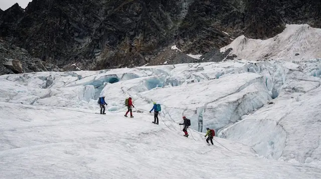
A heli-hike lands you on the upper névé for guided walking among crevasses and ice formations that aren’t visible from the valley floor. If you’d rather combine the flying with something less strenuous, the heli picnic among the peaks near Franz Josef gets you into the alpine terrain without the walking component.
For a longer, more active day that pairs a helicopter flight with hiking and a jet boat run through Wanaka’s backcountry, the Heli Siberia flight, hike and jet boat combination is based out of Wanaka rather than Franz Josef, so it suits travellers doing this trip in the other direction or adding an extra Wanaka day.
If flights are cancelled, the village itself still has value: short walks to lookout points over the glacier valley, the Department of Conservation visitor centre for current access information, and Lake Mapourika a short drive north for calmer scenery. A relaxed way to see the lake without a car is the three-hour kayak tour on Lake Mapourika, which runs regardless of glacier access conditions. Read what the brochure doesn’t say about glaciers before you go, and compare Franz Josef against Fox if you’re deciding how to split your time between the two.
Day 4: Fox Glacier, Lake Matheson, and the return
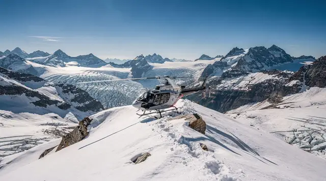
Fox Glacier / Te Moeka o Tuawe is 25 kilometres south of Franz Josef, about 25 minutes’ drive. Fox is the longer of the two glaciers and, like its neighbour, is closed to unguided foot access — helicopter is the only way onto the ice. The scenic helicopter flight with a snow landing at Fox is a shorter, lower-cost alternative to a full heli-hike if you’ve already done one at Franz Josef, or if today is your only remaining weather window.
Lake Matheson sits 6 kilometres from Fox village and is the reason many people build a whole morning around this day. On a still, clear morning the lake reflects Aoraki / Mount Cook and Mount Tasman on its surface — genuinely one of the more striking views on the West Coast. On an overcast or windy day, the reflection simply doesn’t happen, so treat it as a bonus rather than a guarantee, and go early if you want the best chance at still water.
From here, the return to Queenstown retraces Day 2 in reverse: back over the Haast Pass, through Makarora and Wanaka, and either overnighting in Wanaka to split the drive or pushing on to Queenstown if you left Fox early enough. Total return distance from Fox Glacier to Queenstown is around 400 kilometres, close to 6 hours of driving without stops — check driving in New Zealand’s South Island for general road conditions, and if you’re renting for this leg specifically, car rental in Queenstown covers what to check in the contract around alpine passes and winter chains.
What this trip costs and what can go wrong
This isn’t a cheap add-on. Between fuel for roughly 750 kilometres of driving, three nights of accommodation outside Queenstown, and at least one glacier helicopter flight, expect to add somewhere in the NZ$800–1,600 per person range to a Queenstown-based trip, more if you take multiple flights or travel in peak summer. Travel insurance for adventure activities is worth checking specifically for helicopter scenic flights and heli-hikes — plenty of standard policies exclude them, and the ACC scheme that covers accident treatment costs for visitors in New Zealand doesn’t cover cancellation, rebooking, or lost time from a grounded flight.
The single biggest risk to this itinerary is weather closing the helicopters, not the driving. Franz Josef and Fox sit in some of the wettest parts of the country, and a run of low cloud can ground flights for days at a time. If a heli-hike or scenic flight is the reason you’re making this trip, build the spare day into Day 3 as suggested above rather than assuming Day 4 will work out, and check Queenstown’s weather month by month when you’re picking dates — the West Coast’s weather doesn’t always match what Queenstown is doing on the same day, but a wet week over the whole lower South Island reduces your odds on both sides of the alps at once.
Frequently asked questions about this Queenstown to glaciers itinerary
Is this route drivable in a normal rental car?
Yes. State Highway 6 over the Haast Pass is sealed the whole way and doesn’t need a 4WD in dry summer conditions. Check your rental agreement for winter clauses: some insurers require chains between June and September, and a few contracts exclude the pass altogether in snow.
Where’s the last fuel stop before the Haast Pass?
Wanaka and Makarora both have fuel. After Makarora there’s nothing until Haast township, roughly 120 kilometres on, so fill up in Wanaka or Makarora rather than assuming you’ll find a station on the pass itself.
How bad are the sandflies?
Bad, especially at Haast, the West Coast townships and anywhere near still water or rainforest. Te namu bite year-round and ignore light rain. Pack proper repellent and long sleeves rather than relying on what’s sold at the last petrol station.
Can I still walk onto the glaciers?
No. Since 2012, unguided foot access to Franz Josef and Fox has been closed for safety reasons as both glaciers have retreated and the terminal faces have become unstable. The only way onto the ice now is by helicopter (heli-hike), and that access depends entirely on the weather.
How much buffer should I leave for a heli-hike?
At least one full spare day if a helicopter flight is the reason for the trip. Both Franz Josef and Fox sit in some of the wettest weather in the country, and low cloud grounds helicopters more often than it stops road travel. Book heli-hikes early in your stay, not on the last morning.
Is Lake Matheson worth the detour?
Yes, weather permitting. The short loop track near Fox Glacier gives a reflection of Aoraki / Mount Cook and Mount Tasman on the lake’s surface, but only on a still, clear morning — on an overcast or windy day the reflection simply isn’t there, so don’t build your whole day around it.
Should I do this as a loop back through Queenstown, or fly out from the coast?
Most visitors drive it as a there-and-back loop through Wanaka and the Haast Pass on both legs, since there’s no airport at Franz Josef or Fox. Hokitika, further north, has limited flights, but for a four-day trip built around Queenstown, driving back the way you came is the practical option.
How long is the walk to the Blue Pools?
The main track from the Makarora car park is about 20 to 30 minutes each way on flat, well-formed track through beech forest, crossing a swing bridge to reach the viewing platform above the pools. It’s an easy add-on rather than a full walk, and worth timing for good light if you want the water at its clearest turquoise.
Glacier heli-hikes & flights on GetYourGuide
Verified deep-linked GetYourGuide tours. Book through these links and we earn a small commission at no cost to you.
GetYourGuide does not provide a product photo for this activity — the image shows the meeting point, photographed by us.