Aoraki / Mount Cook is the one point on a Queenstown itinerary where the map stops being about lakes and canyons and turns properly alpine. At 3,724m it’s the highest peak in New Zealand, sitting at the head of the Tasman Valley inside Aoraki/Mount Cook National Park, part of the Te Wahipounamu World Heritage Area that also covers Fiordland. It’s a proper detour from Queenstown — 265km and 3h30 each way — so it rewards people who build in a full day, or better, a night in the village at the foot of the mountain.
What draws people here isn’t the summit itself, which very few visitors will ever stand on. It’s the Hooker Valley Track laid out flat beneath it, the Tasman Glacier calving into its own iceberg lake, and a night sky dark enough to see the Milky Way without trying. All three are accessible without technical skill. None of them are guaranteed by the weather.
Where Aoraki sits, and why the number keeps changing
Aoraki takes its name from Ngāi Tahu tradition: in the story, Aoraki and his brothers were sons of the sky father, their canoe wrecked and frozen into the Southern Alps, Aoraki himself turned to stone as the tallest of the peaks. The dual name Aoraki / Mount Cook reflects that history alongside the European name given by Captain Cook’s survey in the 1770s, though Cook never saw the mountain up close.
The height itself is not fixed. In December 1991, a large rock and ice avalanche sheared away part of the summit ridge on the eastern face — one of the biggest such collapses recorded on the mountain. Combined with more precise resurveys since, the accepted height dropped by around ten metres. If you’ve seen an older figure quoted in a guidebook or on a souvenir map, it’s out of date: the current measured height is 3,724m, and that’s the number worth using.
The mountain sits at the centre of a small range of 3,000m-plus peaks, visible end to end from Lake Pukaki on a clear day and from much of the upper Mackenzie Basin. It is also, bluntly, a serious mountain — weather closes in fast, and the summit route is for roped, experienced climbers only, not a hiking objective.
Getting there from Queenstown
There’s one practical road route from Queenstown, and it runs through the Mackenzie Basin rather than along the lakefront scenery most visitors expect from a South Island road trip.
| Route | Distance | Driving time | Notes |
|---|---|---|---|
| Via Cromwell, Lindis Pass, Twizel | 265km | ~3h30 | The direct route; sealed throughout, fuel at Cromwell and Twizel |
| Via Wanaka, Lindis Pass, Twizel | 280km | ~3h45 | Adds Wanaka without much extra time if you’re starting from there |
| Continuing from Lake Tekapo | 65km | ~50 min | Common add-on if you’re already heading toward Christchurch |
There’s no scheduled public bus from Queenstown to the village; a few operators run day tours, but most visitors self-drive. The Lindis Pass climbs to over 970m and can carry snow outside summer — check conditions before you go, and see our notes on driving in New Zealand’s South Island if you’re new to mountain roads. Car rental in Queenstown is straightforward to arrange, though most standard rental contracts are fine with State Highway 80 into the village since it’s sealed the whole way.
Fuel up before you leave — there’s no fuel station in Mount Cook Village. The last stop is Twizel, 65km short of the village.
Walking the Hooker Valley Track
This is the single most popular thing to do at Aoraki, and for good reason: it’s the best view of the mountain you’ll get without a helicopter, on a track anyone reasonably fit can walk.
| Detail | Figure |
|---|---|
| Distance | About 10km return |
| Time | Around 3 hours at an easy pace |
| Elevation gain | Roughly 100m — mostly flat |
| Swing bridges | Three, each swaying in the wind |
| Start point | White Horse Hill car park, 10 minutes from the village |
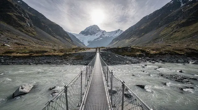
The track follows the Hooker River past braided gravel flats and alpine scrub, crossing three swing bridges that are the main obstacle for anyone nervous of heights — they move, and the wind funnelling down the valley can be strong even on a calm day in the village. It ends at Hooker Lake, a glacial lake often carrying small icebergs calved from the Hooker Glacier, with Aoraki filling the skyline behind it.
It’s an easy grade but not a soft walk: there’s minimal shelter, weather changes fast, and the return leg into a headwind has caught out people who treated it as a casual afternoon stroll. Good footwear and a windproof layer matter more here than the distance suggests. For other options in the area, our guide to walks around Queenstown and the wider Great Walks near Queenstown round-up cover multi-day tracks; the Hooker Valley itself is a day walk, not an overnighter, with the DOC-run Hooker Valley Track guide covering conditions in more depth.
The Tasman Glacier and its iceberg lake
New Zealand’s longest glacier, the Tasman, runs about 23km down from the high peaks of the range, and it’s changed dramatically in the last few decades. Where the glacier once ended in solid ice, meltwater has pooled since the 1970s into Tasman Lake — a body of water that didn’t exist a generation ago and keeps expanding as the glacier retreats, with icebergs calving directly off the terminal face.
There’s no walking route onto the glacier itself. The Tasman Valley road leads to a short track and viewpoint over the lake, and boat trips run onto the lake in season, weaving between floating ice when conditions allow — worth checking ahead, since the lake’s ice cover and access change year to year. For an up-close look at the ice, the only realistic option is from the air; see our Tasman Glacier from Queenstown guide for how that compares with driving to the village yourself.
The retreat here mirrors what’s happening at Franz Josef and Fox on the West Coast, covered in our Franz Josef vs Fox Glacier comparison — all three are retreating at pace, and none of them can be walked onto on foot any more.
Flying onto the ice: scenic flights and heli-hikes
This is where Aoraki earns its place on an adrenaline-adjacent itinerary, even though nothing here involves jumping off anything. Fixed-wing ski planes and helicopters both fly from Mount Cook Village and, weather depending, from Glenorchy and Queenstown, landing on snow in the high basins between the peaks.
A helicopter flight with a snow landing high in the range is the shortest way to stand somewhere genuinely alpine — engines off, snow underfoot, the summit ridge close enough to feel the scale properly.
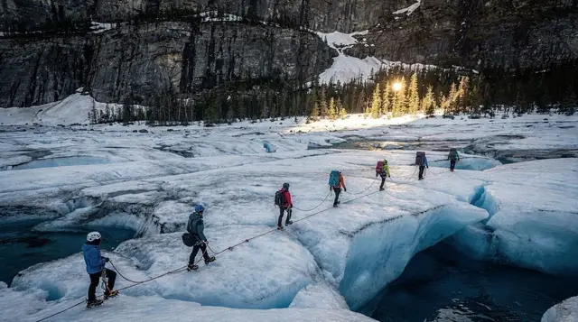
For a longer day on the ice, a heli-hike onto the Tasman Glacier itself flies you in, then has you walking roped and crampon-fitted among crevasses and ice formations with a guide — genuinely the only way left to set foot on that ice. If you can’t decide between flying and hiking, a combined ski plane and helicopter flight covers both aircraft types and multiple landings in one outing.
All of it is entirely weather-dependent. Wind, cloud and visibility around the peaks shut flights down more often than operators like to advertise — build a spare day into your plans if a flight matters to you, and read the cancellation and rebooking policy before paying. Our guide to alpine and glacier landings breaks down what each flight type actually includes, since “scenic flight” covers everything from a 20-minute loop to a full glacier landing.
Aoraki Mackenzie: the night sky
The Mackenzie Basin has some of the least light-polluted skies in the world, largely because so few people live in it. Aoraki/Mount Cook National Park sits within the Aoraki Mackenzie International Dark Sky Reserve, a roughly 4,300km² zone established in 2012 that also covers Lake Tekapo further down the valley.
You don’t need a tour to see it — step outside the village on a clear, moonless night and the Milky Way is visible without any equipment. What you do need is patience with the weather: cloud cover here follows the same unpredictable pattern as everywhere else in the region, and a still, clear night can turn overcast within an hour. If Aoraki is cloud-bound, Lake Tekapo an hour down the road, with its dedicated observatory at Mount John, is the more reliable bet — our stargazing at Tekapo vs Queenstown comparison covers which is worth building a night around.
Mount Cook Village: staying and eating
The village itself is tiny — a handful of accommodation options, a general store, a DOC visitor centre, and not much else, all sitting at the end of the road with the mountain filling the view. That’s the appeal and the limitation in one: nowhere to wander after dark, but nowhere between you and the peak either.
Book accommodation ahead, especially in summer — options are limited enough that the village fills up on clear-weather weekends when everyone chasing a flight or a walk turns up at once. There’s no fuel and limited food shopping, so plan to arrive with supplies if you’re self-catering, and expect prices at the village’s few eateries to run higher than Queenstown given everything is trucked in over the Lindis Pass.
Kea — the alpine parrot found nowhere else in the world — turn up around the village and car parks looking for food and anything shiny to dismantle. Don’t feed them; it’s bad for the bird and it’s how rental cars end up with chewed rubber seals.
Nearby: Lake Pukaki, Lake Tekapo and Twizel
The road in and out passes through scenery worth its own stops. Lake Pukaki, 55km from the village, is the classic turquoise-water, Aoraki-in-the-background photo — the colour comes from glacial flour suspended in the meltwater, the same phenomenon that colours Tekapo. Twizel, the nearest town with real services, makes a sensible fuel and grocery stop in either direction and a cheaper base than the village itself if you don’t mind the extra 65km each way.
Continuing north, Lake Tekapo adds the Church of the Good Shepherd and the Mount John observatory to the same dark-sky reserve; south, the road eventually rejoins the Queenstown route via Cromwell or continues on toward Christchurch. If glaciers are the theme of your trip rather than a one-off, our four-day Queenstown to the West Coast glaciers itinerary strings Aoraki together with Franz Josef and Fox on the other side of the divide, and what the brochure doesn’t say about glaciers is worth a read before you book any ice-focused activity, here or on the West Coast.
Questions about visiting Aoraki / Mount Cook
How far is Aoraki / Mount Cook from Queenstown?
265km and about 3h30 of driving, via Cromwell, the Lindis Pass and Twizel. There’s no direct public transport, so it’s a self-drive, organised day tour, or a stop on a longer South Island route.
Can you still climb to the summit of Aoraki / Mount Cook?
Yes, but only as a serious mountaineering objective with glacier travel, crevasse rescue skills and, usually, a guide — it is not a hike. Most visitors experience the mountain from the Hooker Valley floor or from the air instead.
What happened to Aoraki / Mount Cook’s summit in 1991?
A large rock and ice collapse sheared away part of the summit ridge in December 1991. Combined with later resurveys, the peak’s official height dropped by around ten metres, from earlier figures to today’s accepted 3,724m.
How long is the Hooker Valley Track and is it hard?
It’s about 10km return from the White Horse Hill car park, roughly 3 hours at an easy pace. The gradient is gentle throughout, but three swing bridges and constant wind mean it’s not a stroll to underestimate.
Can you walk on the Tasman Glacier?
Not on foot from the road end. The glacier is heavily crevassed and retreating, and the only way onto the ice itself is by helicopter as part of an organised heli-hike.
Is Mount Cook Village worth staying overnight, or is it a day trip from Queenstown?
Both work. A day trip from Queenstown means roughly 7 hours of driving for maybe 3 hours on the ground, so a day tour or one night in the village gives you far more time for the Hooker Valley Track and a clear-weather buffer for flights.
What’s the best time to see the night sky at Aoraki / Mount Cook?
Any clear, moonless night, but the shoulder seasons combine longer dark hours with more settled weather than midwinter. The area sits within the Aoraki Mackenzie International Dark Sky Reserve, so light pollution is minimal even without leaving the village.
Do I need a 4WD to drive to Aoraki / Mount Cook?
No. State Highway 80 into the village is sealed and open to any rental car in summer. In winter, carry chains and check conditions — snow and ice do close sections of the wider route.