Ten kilometres, no real climb, and the mountain gets bigger the whole way
The Hooker Valley Track is the most walked trail in Aoraki/Mount Cook National Park, and it earns that reputation honestly. It’s 10km return from the White Horse Hill car park to the edge of Hooker Lake, the glacial lake fed by the retreating Hooker Glacier, with Aoraki filling the view the entire way. Three swing bridges, a gravel and boardwalk path, and an elevation gain of roughly 100 metres over the full route. Most people walk it in about three hours, including stops.
That combination — genuinely flat, genuinely spectacular, no technical skill required — is why it gets recommended constantly, and why the car park at White Horse Hill is full by mid-morning most of the year. It is also why people underestimate it. “Flat” gets translated in people’s heads as “easy in every sense,” and the valley doesn’t agree.
What the walk actually involves
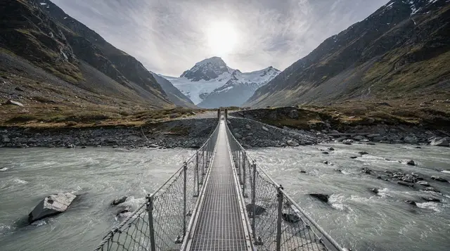
From the car park, the track climbs briefly through a short section of matagouri scrub before dropping onto the valley floor proper. The Hooker River runs milky grey with glacial silt to your right for most of the walk, and the true trail landmarks are its three swing bridges, each one longer and higher than the last:
| Bridge | Approx. distance from car park | Notes |
|---|---|---|
| First swing bridge | 1.5km | Crosses the Hooker River, gentle introduction |
| Second swing bridge | 3km | Longer span, more noticeable movement underfoot |
| Third swing bridge | 4.3km | Closest to the terminal lake, usually the windiest crossing |
Past the third bridge, the track climbs a short rise and drops you at the shore of Hooker Lake, a milky turquoise glacial lake with small icebergs calved from the Hooker Glacier drifting across it on calm days. Aoraki, at 3,724 metres the country’s highest peak, sits directly behind it. This is the payoff, and it’s the reason the walk gets photographed as often as it does: it is one of the few places in New Zealand where a ten-kilometre round trip on a formed path delivers a high-alpine glacier scene usually reserved for multi-day tramps.
The return leg follows the same path back to the car park. Budget the full three hours; rushing it defeats the point, since the light and the mountain change constantly.
The catch: “flat” is not “sheltered”
This is the one thing worth repeating before anyone drives 265km to walk it. The Hooker Valley is a glacial trough, essentially a wind tunnel running straight down from the ice, and it funnels air with real force. On a still day in Twizel or Lake Tekapo, the valley itself can be gusting hard enough to make the swing bridges genuinely unpleasant to cross, and hard enough that DOC will close the track outright in the worst conditions.
There’s no tree cover, no ridgeline, nothing to break the wind anywhere along the route. A jacket that’s fine for a stroll around Lake Wakatipu in Queenstown is often not enough here. Bring a proper windproof shell, not just a light layer, and expect the temperature to feel several degrees colder than the forecast once you’re standing on the third bridge with the glacier air coming straight at you.
The practical upshot: check the Department of Conservation’s Aoraki/Mount Cook alerts before you drive out. Bridges do close for maintenance or storm damage, and the whole track occasionally closes in extreme wind or after heavy rain has damaged the path. A wasted 3h 30min drive each way is the actual cost of skipping that check, not just an inconvenience.
Best light, best time of day
Early morning is the strong recommendation, for two separate reasons. First, the practical one: the White Horse Hill car park is small relative to how popular the walk is, and it fills well before 9am for most of the year, especially December to February. Arriving at sunrise, or within an hour or two of it, means an easy car park and a much quieter trail.
Second, the photographic one: Aoraki catches the first light of the day well before the valley floor does, and mornings tend to be calmer than afternoons before the day’s wind builds. Cloud also has a habit of forming around the summit by early-to-mid afternoon, particularly in summer, so a mountain that was clear at 7am can be obscured by 1pm. If seeing Aoraki clearly matters to you — and for most people doing this walk, it’s the entire point — morning is not just nicer, it’s more reliable.
Getting there from Queenstown
The drive is 265km and takes about 3h 30min, running via Cromwell, the Lindis Pass, Omarama and Twizel before turning onto the final approach road into the national park. It’s sealed the entire way and doesn’t require anything beyond a standard rental car, but it is a long way to go and come back in a single day.
Doing the whole thing — drive, walk, drive back — from Queenstown in a day is realistic but demanding: most people leave before 7am and get back into Queenstown well into the evening, with limited time to linger at the lake. A comfortable version of the same trip breaks the drive with a night in Twizel or Lake Tekapo, which also puts you closer to the Mackenzie Dark Sky Reserve for stargazing once the sun goes down. See our Queenstown to Mount Cook guide for the full route breakdown, or the driving in New Zealand’s South Island guide if it’s your first time behind the wheel here.
For anyone who’d rather not do 7 hours of driving in a day, a scheduled tour or a scenic flight covers the same ground without the fatigue. A helicopter tour and hike departing from Queenstown lands you inside the national park directly, which trades the long road trip for an aerial approach and still leaves time on the ground near the glacier.
Pacing the walk and what to look for
The easiest way to enjoy the Hooker Valley Track is to stop treating it as an out-and-back sprint to the lake. The path is wide and well formed, so there is no technical reason to hurry, and the best moments tend to arrive between the bridges rather than at them. Stop on the boardwalk sections and turn around: the view back down the valley is quieter than the one ahead, and it gives you a sense of how much ground the glacier once covered.
Keep an eye on the river too. The grey, silt-heavy water changes colour with the light and the weather, and on bright mornings it reads as a pale milky blue that matches the lake at the far end. Alpine plants cling to the gravel on either side of the path, and the scrub near the start gives way to open tussock as you move deeper into the valley. None of it needs a guidebook, but slowing down is what lets you notice it.
At the lake itself, give yourself time rather than turning round after a quick photo. The shore is a good place to sit out of the wind for a few minutes if you find a spot behind the rocks, to have a snack, and to wait for the cloud to shift if Aoraki is hiding. Patience here is often rewarded: the summit can clear in the space of a coffee. Stay on the marked path and keep to the designated viewing areas at the water’s edge, which exist to protect the fragile ground and to keep walkers away from unstable banks.
Who the walk suits, and who might struggle
Because the gradient is gentle and the surface is formed, the track suits a very wide range of walkers: first-timers, people who rarely hike, and older children who can keep a steady pace for several hours. It is a good choice for a family that wants a proper outing without a steep climb, and our Queenstown with kids guide is worth a read if younger travellers are in the group.
The people most likely to struggle are those who are nervous about heights or movement underfoot. The swing bridges sway, and they sway more when other walkers are crossing at the same time, so anyone who dislikes that sensation should expect the second and third crossings to be the hard part, not the distance. Walkers who set out in light clothing and treat it as a stroll are the other group that turns back early, because the cold air coming off the glacier catches them out.
If the group includes people with very different paces, agree a meeting point at the lake and let everyone walk at their own speed. The path is clear enough that nobody will get lost, and the faster walkers can enjoy the lake before the others arrive.
When the weather turns
The weather in the Mackenzie Basin and the national park can change faster than the forecast suggests. A morning that starts clear can turn grey and windy within hours, and rain in the valley often means the mountain disappears entirely. If the day looks poor when you wake up, it is worth reading our best time to visit Queenstown and weather month by month guides before committing to the long drive, and having a fallback plan.
A fallback does not have to mean giving up on the trip. A cloudy day is still a good day for the drive itself, with the Lake Pukaki viewpoint and the stops along the way, and a night in Twizel gives you a second chance at a clear morning. If you are based in Queenstown and the forecast looks bad for the whole stretch, the rainy-day ideas in our Queenstown on a rainy day guide are a better use of the time than a long drive to a hidden mountain.
What to pack
| Item | Why |
|---|---|
| Windproof shell jacket | The valley wind is the single biggest discomfort factor, even on a warm day |
| Sun protection (hat, SPF50+) | UV is intense here even under cloud, and there’s no shade on the entire route |
| 1-1.5 litres of water per person | No water source on the track; it’s flat but still a 3-hour walk |
| Sturdy shoes, not sandals | The path is gravel and boardwalk, uneven in places near the bridges |
| Layers rather than one heavy coat | Temperature swings noticeably between the car park and the exposed bridges |
Extending the trip beyond the walk
For visitors with more time or budget, Aoraki/Mount Cook National Park has options well beyond the valley floor. A scenic flight over Aoraki and the surrounding glaciers shows the terrain the Hooker Valley Track only hints at from below, including the Tasman Glacier and its terminal lake.
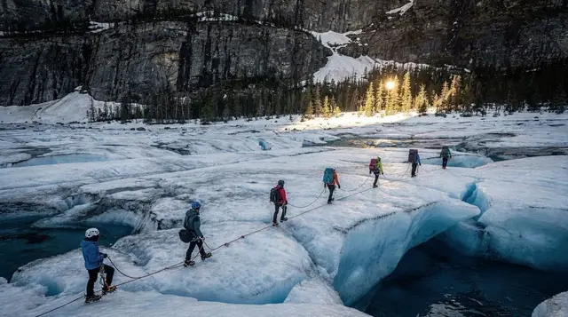
For a closer look at the ice itself, a heli-hike onto the Tasman Glacier — since 2012 the only way to actually walk on these glaciers — is bookable as a heli-hike to the Tasman Glacier. Both are genuinely dependent on weather and get cancelled more often than operators like to advertise; build a spare day into the itinerary if either is a priority, and see our alpine and glacier landings explained guide before booking.
Base camps for exploring further afield: Twizel is the closest township with accommodation and fuel, Lake Tekapo adds the Church of the Good Shepherd and Mount John Observatory to the mix, and Lake Pukaki, on the drive in, has some of the best unobstructed views of Aoraki in the entire region without leaving the car.
Making a night of it in the Mackenzie Basin
Spending a night near the park changes the whole character of the trip. Instead of watching the clock for the drive back, you can walk early, take a slow lunch, and still have daylight left. Staying in Twizel or at Lake Tekapo also makes it easy to combine the walk with the stargazing described in our Lake Tekapo stargazing blog post, which many travellers remember longer than the walk itself.
If you are building a longer loop, the Queenstown in 3 days and Queenstown in 5 days itineraries show how a Mount Cook night can fit between the lakes and the adrenaline activities without wrecking the rest of the schedule.
How it compares to other walks near Queenstown
Nothing else within day-trip range of Queenstown offers this ratio of effort to alpine payoff. The Routeburn Track and other Great Walks require multiple days, proper tramping fitness and, for the Great Walks proper, advance hut bookings that open each May. Closer to town, walks around Queenstown itself — see our best hikes around Queenstown guide — tend to be shorter climbs with lake or town views rather than a glacier at the end of them.
The trade-off is the drive. The Hooker Valley isn’t a Queenstown walk in any real sense; it’s a Mackenzie Basin walk that happens to be reachable from Queenstown in a long day. Anyone weighing it against day trips from Queenstown closer to the Milford Sound day trip or the wineries of Gibbston should factor in that 3h 30min each way honestly, not as a rounding error.
Hooker Valley Track: your questions answered
How long is the Hooker Valley Track and is it hard?
It’s 10km return from White Horse Hill car park, crossing three swing bridges to the Hooker Lake, and takes about three hours at an easy pace. The gradient is gentle throughout, but it’s an exposed valley floor with no shelter, so wind and weather matter more than fitness.
Is the Hooker Valley Track really flat?
The elevation gain is minor, only around 100 metres over the full 10km, and the surface is a formed gravel path with boardwalk sections. But flat doesn’t mean sheltered: the valley funnels wind straight off the glacier, and gusts on the swing bridges are the main reason people find it harder than expected.
Do I need to book or pay to walk it?
No booking and no fee for the track itself. Aoraki/Mount Cook National Park has no entry charge. The only cost is petrol to get there and, if you want one, a coffee or pie at the village before you leave.
What’s the best time of day to go?
Early morning, ideally within an hour or two of sunrise. Wind tends to build through the day, cloud often rolls in over Aoraki by early afternoon, and the car park at White Horse Hill fills before 9am in summer.
Can I do the Hooker Valley Track as a day trip from Queenstown?
Yes, but it’s a long day: about 3h 30min each way, plus the 3-hour walk, plus stops. Most people who do it from Queenstown leave before 7am. Staying a night in Twizel or Lake Tekapo turns it from a rushed 12-hour day into a relaxed one.
Does the track ever close?
Yes. The Department of Conservation closes sections in high wind, heavy rain or after damage to the swing bridges, and the bridges themselves are occasionally closed for maintenance. Check the DOC Aoraki/Mount Cook alerts page before you drive out, not after you arrive.
What should I pack for a flat walk?
A proper windproof shell, not just a light jacket, sun protection even in cloud because the UV here is intense, and more water than a 10km flat walk would normally suggest, since there’s no shade and no water source on the track.